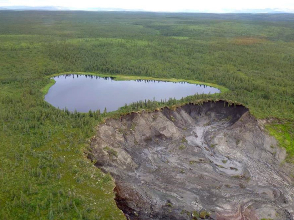
This past July a permafrost retention wall holding back a lake in Canada’s Northwest Territories gave way, dumping half its contents—some 30,000m3 of water—into the surrounding countryside and creating a 2km trail of muddy debris.
But the video (shown below) detailing the true extent of the event was just released last week, compliments a remote camera that caught the disaster from start to finish. And with visual evidence in tow, this summer’s collapse seems even more disturbing, particularly in light of the fact its by no means projected to be an isolated, or even unusual event.
While the two-hour flooding event has been described as catastrophic, the resulting investigation has been slow—though plenty of the facts are known. The Northwest Territories Geological Survey has been monitoring climate change induced landscape changes and geohazards in the region, Peel Plateau—some 20km outside Fort McPherson—for quite some time now. The group’s also enlisted the help of local universities, other government agencies and the Tetlit Gwich’in Renewable Resources Council to look into the matter.
The impacts of climate change are already being felt worldwide, but especially in northerly locales where decades of rising temperatures have lead to the melt and subsequent loss of huge swaths of ancient ice flows and permafrost, or frozen-soil deposits.
Though often overlooked because it’s buried in the Earth, permafrost layers cover a quarter of the Northern hemisphere, and hold around two times the amount of carbon as present in our current atmosphere. Canada has massive reserves and it’s predicted that in the next 100 years a permafrost area the size of Australia will be lost.
The Geological Survey was well aware that the specific lake in question’s slopes had been weakening for about a decade, suffering from a phenomena called permafrost slump where the landscape gains deep craters and scars as ice preserved in the frozen-soil’s chilly embrace melt. They’d issued warnings that the lake’s banks were becoming unstable and that the inland body of water would ‘drain catastrophically during 2015,’ the most recent just a month before in June.
Now that the damage has been done and the video evidence is in play, showing the lake rapidly evacuate itself over the blown retention wall in a five-story high waterfall, it may be hard to believe that the whole event could have been far worse.
The lake’s water and muddy post-ice slurry mixture wound up flowing into a larger lake, part of the McKenzie Delta, some 5km away. Though it did cause marked murkiness and fill some 2km of the surrounding valley, things have begun to settle. The Geological Survey notes that ultimately no one was hurt, and the drainage event could have been much larger—the slump erosion halted when it hit unfrozen soil.
But there’s still another half of the lake left to drain, and it’s too soon to tell what the long-term environmental repercussions of the huge quantity of organic debris released during the collapse will be.
The Geological Survey and partners note in 2016 they’ll be trying to develop more sensitive tools to better predict and monitor such natural disasters—and they’re not alone. Researchers in the United States are reporting that the bleak permafrost projections for Alaska’s northern regions will likely begin much sooner than anticipated.